Wednesday, August 20, 2014

Big Hole National Battlefield Monument

 In the summer of 1877 five bands of Nez Perce Indians consisting of 800 people, including 250 warriors, began a 1,170 mile journey from northeastern Oregon and central Idaho over the Bitterroot Mountains and through the Montana Territory. Though they were herding more than 2,000 horses and carrying whatever possessions they could manage, the Nez Perce made this long and difficult trek in less than four months. United States Army troops under General Oliver O. Howard had orders to place these five bands of Nez Perce on a small reservation in central Idaho. The Nez Perce had hoped to elude the soldiers, but they were forced to stop and face their pursuers several times. The battle with the highest number of casualties during this epic odyssey took place in the Big Hole Valley of southwestern Montana. The Battle of the Big Hole was a tragic turning point of what came to be called the Nez Perce War of 1877. The view above is from the visitor center, looking down on the battlefield. Teepee poles can be seen in the same spot where the original encampment was placed.

 We took the trails leading to several points in the battle. From this viewpoint we could look down on the entire valley.

 The soldiers attacked from the forested hillside, here showing the bushes and trees growing along a winding creek.

 A monument has been erected telling the names and numbers of soldiers lost in the battle. The army, under the control of General Howard, conducted a sneak attack on the sleeping Indians early in the morning. 60 to 90 members of the tribe were killed, mostly women, children and the elderly. The warriors quickly launched a counter attack where 29 soldiers were killed and 40 wounded. In a military sense, the Nez Perce won the battle, but had to continue to flee.

 We were tired from our hike on the hillside, but we absolutely had to take the trail leading out to the Indian encampment on the valley floor. Imagine our shock and surprise when this majestic moose crossed our path right in front of us. I barely got the camera turned on in time! We sneaked around the bush to see where he'd gone and found him looking at us. I snapped another photo before he gracefully leaped away into the bushes. I remembered the sign at the beginning of the trail warning us to stay away from any wild animals we might encounter! We had gotten a little closer than we should have, but it was the moose's doing, not ours!

 These teepee poles were erected in recent years by Native Americans honoring their dead. The entire valley is preserved as a burial ground, undisturbed and treated with the respect due to these tragically wronged peoples. (Click to enlarge.)

We could almost hear the wails and the cries of the women, children and elders who were attacked without warning. Thunder and lightning surrounded us, adding to the spirit memories
of the long ago Nez Perce travelers. Some of the most heart-rending words I've ever read were spoken by Chief Joseph as part of his tribe escaped into Canada while he stayed behind caring for the weak and sick ones.
"I am tired of fighting. Our chiefs are killed...It is cold and we have no blankets. The little children are freezing to death...My heart is sick and sad. From where the sun now stands I will fight no more forever."

Tuesday, August 12, 2014

Philipsburg, Montana

 Today, Philipsburg, an old Montana mining town, was on our agenda. The map said we'd go about 50 miles on I-90, then 20 plus on the scenic Pintler Loop to Philipsburg. Well, always one to want to avoid the freeway, Mr. Keith asked if there were another way. There was the Rock Creek Road, a gravel and dirt road that did indeed come out at the town, but whose condition was unknown to us. We loved the scenery along the creek, but the road got more narrow and more bumpy as we went along. After 20 miles we came across a worker who advised us that the road only got worse and worse and she would never take her car on it, so we reluctantly turned around and retraced our miles back to the freeway. An hour later we'd reached our destination.

 Philipsburg was founded in 1867 and grew rapidly at a “rate of one house a day,” and by year’s end had reached a population of about 1,500 residents. At the height of its prosperity, Philipsburg enjoyed the mining boom of the late 1800s, and today honors that past. The town is fully occupied and caters to tourists. On this hot day, the streets were lined with cars and the sidewalks with people going in and out of the many gift shops, museums, and of course the famous Candy Palace, the largest candy store we'd ever been in. We succumbed and bought a bag of delicious taffy made on site.

 At last, we were able to have the buffalo burger I've been wanting since we came to Montana at the beginning of the season! The Doe Brothers' Restaurant was in an old original store, one with the high ceilings and creaky wooden floorboards. We split the burger, since we can't eat that much any longer! Today we stayed mainly in the town. Philipsburg also has garnet mining for the tourists, and a mostly ruined ghost town called Granite up in the hills above the town. We'd toured those before but because of our late arrival after our Rock Creek exploration we chose to stay closer in.

 I had to snap a photo of this unusual blue-eyed, brown-eyed and friendly doggie named "Annie"!

 This majestic building has "High School" carved into the tower, but actually houses kindergarten through 12th grade. It was built back when the town was founded and is still in use around 150 years later.

 The Pintler Highway goes through this beautiful valley, so typical of the western Montana scenery. There were cows everywhere, peacefully grazing the day away.

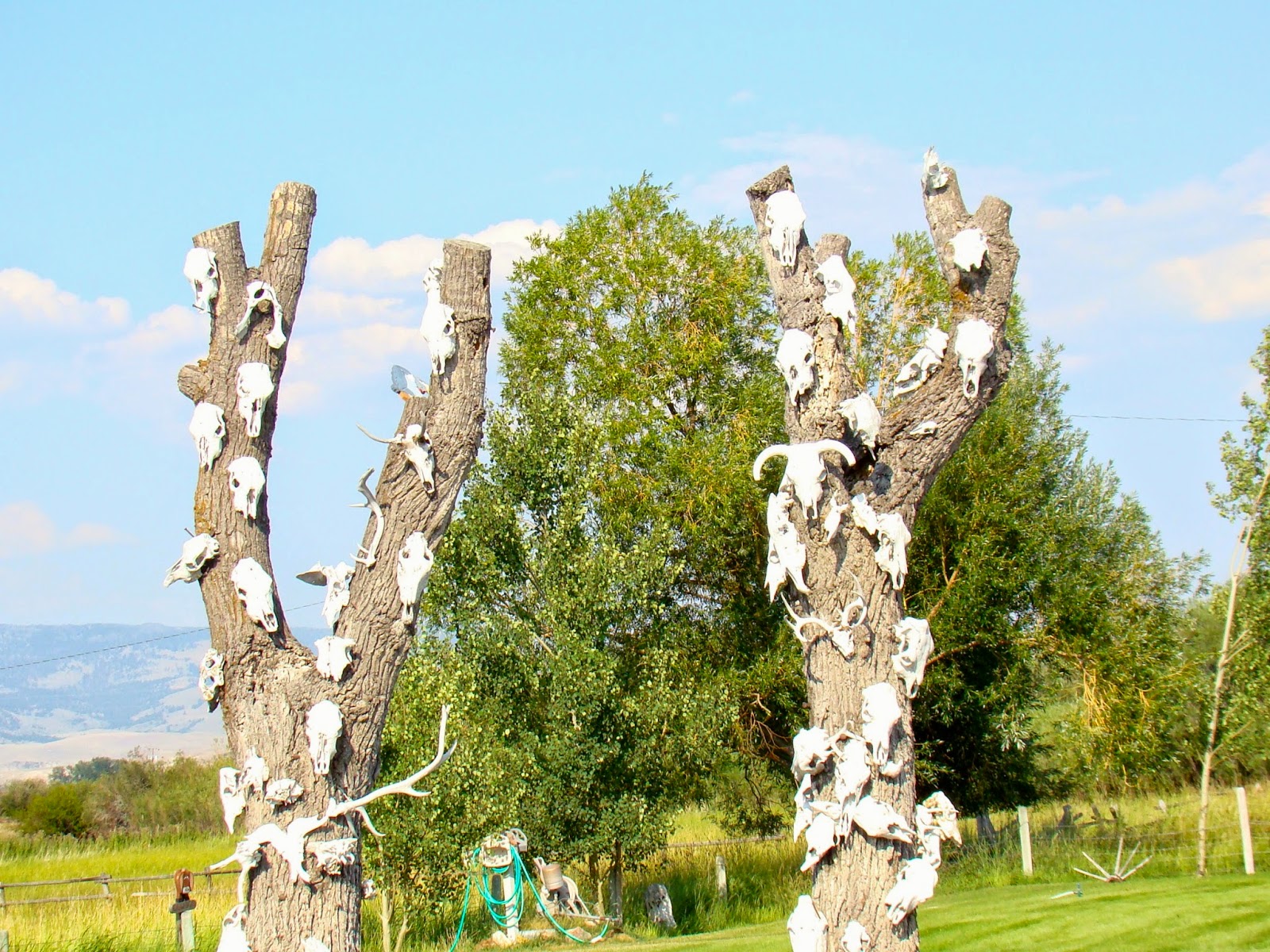
We were intrigued by this odd tree stump decoration. It looks like a variety of cow, mountain goat, deer, and maybe some other assorted horns and antlers. All in all, our trip today was rewarding and we learned more about Montana history. The best part may have been the taffy and the buffalo burger!


Monday, July 28, 2014

Garnet Ghost Town

 We'd been to Garnet Ghost Town in Montana before, when the granddaughters were with us 4 years ago, but we decided it was worth another visit. We were hoping to see some wildlife up there, and as we turned off the highway onto the winding uphill road we did spot one species, perhaps not so wild.

 "There's gold in them thar hills." From the overlook we could see the main street and all that's left of the once prospering gold rush town, established in the very late 1800s. The cabin in the front was a home, while the other buildings include 2 saloons, a merchantile, and the hotel. Prospectors' cabins are seen marching up the hillside.

Two of our potential miners, Natalie and Keith. We are always surprised at the height of the cabin doorways. Folks in those days must have been shorter than we "modern" people. All the buildings are kept up just so they won't fall down, but otherwise they remain as they were left.

We tried to imagine what it would have been like to live in one of these tiny abodes. The miners must have only used them for sleeping and for a place for their possessions. The hillside was covered with wildflowers. I'd have taken more photos, but right here was where my camera battery died. That will teach me to carry the spare with me and not leave it in the car.

We did finally get to see some wildlife, but, surprisingly, it was back in Missoula. We drove around the University, and there she was, a beautiful doe not the least nervous as we snapped pictures.


Sunday, July 27, 2014

Parsons Ponies


One of our most fun jobs at the Missoula KOA has been to help out every Friday evening with the pony rides provided by Parsons Ponies and the KOA. We've had a crowd of kids and their proud parents lined up each time, eagerly awaiting their turn to ride. Suzi brings 3 ponies and the kids are allowed to choose which one to ride. This is Dave, leading a thrilled little boy on Frosty. Mr. Keith is the photographer.  http://www.parsonsponies.com/

Suzi is very careful to make sure each child is properly seated on the pony. She instructs them about the saddle, how to hold on, where to put feet, and then walks beside them calmly explaining about the pony and about riding horseback.

A hot day for riding, but no less exciting for the young ones! The pony rides take place in one of the KOA's fenced dog enclosures and are provided free of charge for the registered campers.

Our granddaughter Natalie, age 13, is spending 2 weeks with us. I believe the most happy times for her have been helping out with the pony rides. She's had some experience with riding at her other grandma's ranch, and she possesses a calm and careful way with children. Suzi has encouraged her and taught her the process of giving children these memorable times during their camping experience at the KOA.

We were thrilled to be invited out to Suzi and Dave's ranch south of Missoula to see all the ponies and some of the bigger horses. Suzi brought out the biggest horse, Henry, for Natalie to ride. Once again, she carefully instructed her rider in every aspect of saddling up and preparing Henry to be ridden. She even showed Nat how to clean out Henry's hooves prior to fitting him with special shoes for the ride.

A happy cowgirl out in the beautiful Montana pine forest at the ranch!

This photo is a priceless one of Natalie, back at the KOA getting ready to lead out one of the ponies for the waiting young campers. We have made plans to go back to Parsons Ponies, the ranch, for one last ride on Natalie's final day with us before returning home. I know she will long remember the awesome experience given to her by this wonderful couple and their equine friends in gorgeous Montana!


Tuesday, July 1, 2014

Packer Meadows

Our day off this week turned out to be beautiful, sunny and clear, a perfect day for a trip. We had been encouraged to travel up to Lolo Pass, the border between Montana and Idaho on Hwy 12, to see the summer crop of camas flowers. On the way we got a great shot of Lolo Peak, elevation 9,143. From Wikapedia: The name "Lolo" probably evolved from "Lou-Lou", a pronunciation of "Lawrence," a French-Canadian fur trapper killed by a grizzly bear and buried at Grave Creek. The first written evidence of the name "Lolo" appears in 1831 when Hudson's Bay Company fur trader John Work refers in his journal to Lolo Creek as "Lou Lou." In an 1853 railroad survey and map, Lieutenant John Mullan spelled the creek and trail "Lou Lou." However, by 1865 the name was shortened to Lolo and is currently the name of a national forest, town, creek, mountain peak, mountain pass and historic trail in west central Montana.

After a quick stop at the Lolo Pass Visitor Center for directions, we found our way, on a dirt road, to Packer Meadows, a gorgeous field bursting with the lovely camas flowers as well as many other kinds of wildflowers. We gazed at a sea of blue in every direction!

Learning that the Nez Perce Indians depended on the camas flower, I looked up the use of the plant. It was sought out by many native peoples in the western U.S. and Canada. The bulb looks and tastes somewhat like a baked sweet potato, but sweeter. When dried, the bulbs can be pounded into a flour. Camas bulbs contributed to the survival of members of the Lewis and Clark Expedition of 1805 and 1806. It would fun to have a taste, but I realize digging wildflowers is not allowed in an historical place!

Another view of these gorgeous flowers.

An additional treat for us, as we traveled slowly along a 7 mile, very primitive road to the south of the Pass, was seeing what seemed like millions of spectacular bear grass blooms. They were covering the hillsides along the way. We had an amazing day, filled with not only these two delightful species, the camas and the bear grass, but also many other lovely wildflowers amidst high country forests. We live in a magnificent country!

Monday, June 16, 2014

To See Some Alpacas!

There are many sights to see going down the Bitterroot Valley. This church in Stevensville is the oldest building in Montana, St. Mary's, established in 1841 by Father Pierre DeSmet. Father Ravalli manned this mission until his death in 1884. I love the backdrop, the beautiful and imposing Bitterroot Mountains.

We traveled down the Eastside highway which must have been the old road before the freeway was built. This old farm is striking with its original farmhouse and rustic outbuildings.

Just east of the small community of Victor we found the Rocking L Alpaca Ranch we'd set out to see. The owners gave us a personal tour, personal because we were the only tourists there! There are 38 alpacas altogether, along with 2 "guard" llamas. These critters do not like to be petted, even though they are completely tame. We loved the little one, who stuck close to mama. Isn't his red "onesie" sweater cute? They would come up close to us and stare with their big, black eyes, checking us out. Inspection complete, they would turn away as though we were fairly boring creatures with no treats in hand!

The alpacas had been shorn just 2 weeks earlier, so looked skinny and naked, except for their furry heads. We could still see the lines the sheers made on their coats. We learned this takes place about once a year. The fur is then woven to make beautiful scarves, hats, mittens and other lovely products. Most of the completed garments we saw were sent from Peru, though the fleece from these guys was made into yarn for purchase. If I were a good knitter, I could have made my own garment! We did purchase a scarf from the gift shop. (Spoiler alert: it's a gift for someone!)

True to our habit of always driving through the oldest, original parts of the towns we pass through, we did that in Hamilton, an old settlement with lots of character.

Since we had toured the historic Daly Mansion in Hamilton during our last stay in Missoula, we just drove down the long driveway this time. So pretty!


Once again driving the back roads we passed through another very small settlement named Corvallis and saw this majestic mansion. We noticed a sign advertising it as a book store. We enjoyed our day trip today to see alpacas, and many lovely places along the way. There is so much to see in gorgeous western Montana.


Tuesday, June 10, 2014

And There Were Bears!


 Finally, a day trip! We decided to tour the National Bison Range, about 40 miles from Missoula. We'd been there before, 4 or 5 years ago, and had enjoyed the spectacular beauty. Bison are awesome, but the views of the Mission Valley from this place are beyond compare. We did see some bison last time but not much else on the day we'd picked. On this trip we were much more fortunate. Our first viewpoint showed us the Flathead River far below. The gravel road through the Bison Range is 19 miles, one way, and narrow.

 It was thrilling to catch a glimpse of a black bear, but then... yes, there were 2 cubs cavorting just above her on the hillside. Mama bear is in the lower center of the photo, and the cubs are slightly higher. Click to enlarge, and you might see them.

Here is my favorite view of all. We walked out on a quarter mile trail to find this breathtaking view, looking east. I can't imagine any sight more beautiful. 
 The Montana state flower is the Bitterroot. I am always searching for wildflowers, so imagine my excitement to find lots of these pink beauties as we hiked along the short trail high in the Range. The only other Bitterroot I'd ever seen was in Eastern Washington many years ago, near Quincy.

 Bunches of them!

 Just for fun, as I got out of the car to photograph a valley scene, I snapped this pretty butterfly.

 This is the gorgeous view looking down into the Mission Valley and up at the stunning Mission Mountains, south of Glacier National Park.

 Heading down from the highest point of the Bison Range we encountered this sign, "Lake Missoula - Highest Level". Here is a link to an excellent web page filled with lots of information about Glacial Lake Missoula.
  http://hugefloods.com/LakeMissoula.html

 We were lucky to see 2 deer with fawns far down in one valley . The young ones would leap and bounce a distance away from mom, then bounce right back. They repeated this several times as we watched. They were too far away for a photo. This lonely deer was having a feast down in the lower part of the Range, near the road.

 Once down from the heights and back on the main road we came across this historic Catholic Church. What a beautiful setting!

 We kept hearing a Meadowlark nearby and I finally spotted him, high on the cross, singing his heart out in praise of the gorgeous countryside.

And last, as we made the circle back to Highway 93, we drove by the beautiful St. Ignatius Church in the town of the same name. Several years ago we went inside to see the amazing paintings on the walls and ceiling. This trip we were too tired. Maybe next time!