Thursday, July 22, 2010

Another Montana Ghost Town

The town of Philipsburg, on the Pintler Scenic Loop, is on the National Register of Historic Places. Most buildings are solid brick and stone, and are fully occupied as businesses or as gift shops, restaurants, and other touristy attractions. The town was a prosperous mining burg in the late 1800s and is now restored to look as it once did. The building above is the high school, still in use.

And here is the jail! It seemed to be still used as a police station, and maybe still as the jail. We walked up and down the streets, crowded with tourists, bought some awesome homemade fudge in the famous "Sweet Palace", and ate a delicious lunch at a restored saloon now used as an eating establishment, "Doe Brother's Fountain and Restaurant."

The ghost town of Granite, in the hills above Philipsburg, presented quite different scenes from the town of Garnet, which we visited a couple of weeks ago. Garnet contained many wooden structures still in place, while Granite was obviously built mostly with stone and brick, and those buildings were lying in ruins, decimated by weather and scavengers. Granite, like Garnet, is up high in the hills, reachable by a narrow dirt road.
 
This is the remainder of the only bank in Granite.

Here we were amazed to see the ruins of a 3 story brick and stone edifice used as the Miners' Union Hall, where the miners found rest, relaxation and entertainment. Trees and bushes have taken over the floor area, and I was surprised to find many raspberry bushes growing here and there over the town property. Someone must have cultivated them when the town was new, and the years and the birds have spread them around.
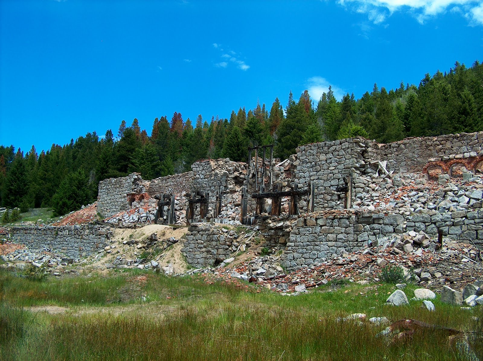
This was perhaps the most fascinating ruined structure we saw. It was once the stamp mill, where the ore was crushed to extract the metal. It is amazing to think how these early miners could construct these edifices without the machinery we have today. This mill was made of huge boulders and bricks, all covered with a wooden facing. We could still see the massive amounts of dust the mill produced.

Here is a wooden house along the way, still more intact than many of the other buildings, most of which were simply holes in the ground surrounded by rock foundations.

The view from the top was spectacular. Looking down, we could see the light-colored dirt left from the mining process, and beyond that, the valley below; such a beautiful sight. Montana has so much awesome beauty, which we are thankful to be able to enjoy.

Click on any of these photos to enlarge.

Wednesday, July 7, 2010

A Ghostly Day!


 We had a day at the Garnet Ghost Town, east of Missoula. Here's a great photo of the wildlife we saw on our way up the mountain. Free range cattle were abundant, grazing throughout the forest.


Here's a view looking down on the town from the pathway near the parking lot. The town of Garnet was born in 1895, a gold mining town, and within several years 1000 people called it home. This is all that is left today.


 My granddaughters and we were looking hard for ghosts!

 
This is one of the better preserved rooms in the hotel.

Push hard, Natalie!

One of 2 or 3 bird nests we saw on the buildings.

Saturday, June 19, 2010

Proud Family!


A very proud family! My daughter is now an RN! We attended the graduation in Wenatchee on Friday, followed by a delicious barbecue at Betsy's house. It was a highlight of our lives. She's accomplished so much in her four years of classes and clinicals, raising two daughters and working besides. God is good! In this picture — Mom and Keith, Mom-in-law and Mike, and Betsy's daughters.

Wednesday, June 16, 2010

Out Walkin'

Just for fun — this is the first view incoming campers have of the Missoula KOA, our 5th wheel! We love this spot because there is no one on the door side of us and we can see everyone entering and exiting the park. We have a lovely flower bed next to us, and the KOA sign lights our way at night.

We found a great walking trail right downtown bypassing this old train station, now on the National Register of Historic Places. The trail and the station are on the banks of the Clark Fork River.

Isn't this a great view? It's the underside of the Orange Street Bridge, also on the walking trail. We hope to explore many more of the hiking trails in the area.


Thursday, June 3, 2010

National Bison Range


We set out to take a short ride into the hills around Missoula, but our ride turned into a day trip on back roads, ultimately taking us to the National Bison Range, north of Arlee. On the way, on Highway 93, we passed under this "Animal's Bridge". Last summer, as we drove through road construction, we wondered why they were installing a huge culvert on top of the road. I thought then that it might be one of those 'over the freeway' animal crossings. Sure enough, it is. There are 2 or 3 more animal crossings along here going under the road. I feel happy that Montana cares about its animal population and does what it can to prevent road kill. (Click to see the sign close-up. You can also see the written Flathead Indian language, since this is on the Flathead Reservation.)

                  
The grass is always greener? Yes, in this case it was!


We couldn't resist this photo of a longhorn resting in the field with other, more common cattle, including a few newborns. Near the entrance to the Bison Range we also saw some very strange looking critters. I thought "Yaks" and proved myself correct when I looked them up on my handy, dandy iPad. I didn't get a picture, though.


The National Bison Range includes some very high hills above the very flat lands below. It features a narrow, winding, one-way dirt-gravel road taking us 19 miles around the reserve. From this vantage point we could look down on the route we'd just traversed, and see the beautiful Flathead River flowing through its valley. All of the places in this post are on the Flathead Reservation.


We've seen so many bison (or buffalo) in the Black Hills that we weren't too excited to see some here in Montana. But this trip turned out be the highlight of our time in Montana, because of the views and the billions of glorious wildflowers. Our "ooohhhs" and "aahhhhs" kept coming. What an awesome imagination God has! Here is my favorite picture. We took a 1/4 mile walk out onto a promontory and were rewarded with this wonderful scene, the flowers, and the steep descent to the valley below.


Here is Keith amongst the beauty. It was a chilly, windy, overcast day, but the flowers brought us sunshine!


A look down into the flatlands below — the white line is a gravel road going somewhere straight away to the north! This area is near St. Ignatius, where we visited an old, historical and beautiful mission church last summer. Farther north is Glacier Nat'l Park. This is also supposedly part of ancient Glacial Lake Missoula. The hill where we were standing boasts the highest level of the lake.


And, just to prove we were on bison land, here they are, one small part of the herd grazing amidst the wildflowers. We also saw 4 pronghorns, 2 deer, and a pheasant!

Friday, May 28, 2010

A Pleasant Day.


Just for fun — Montana, our black cat, had this rug all the way off the step, and then somehow put it back with himself under it!


We went for a hike in the foothills around Missoula, off the Blue Mountain Road. There are myriads of trails in the valley and over the hillsides. It may take us all summer to explore even a small portion of them. Here's something I'd never noticed before, the male strobili on a ponderosa pine. I'm guessing the pine cone forms on the end of the branch after the flowering part falls off. I couldn't find an exact description of the process when I 'googled' the tree.


I liked this old snag with a birdhouse attached.


Here is a shot of the Missoula Valley looking northeast, taken from the trail we were hiking. The water tower in the center is in old Fort Missoula, restored as an historical monument. You can barely see the 'M', a white speck on the hill slightly left of center, and the 'L' on the hill to the far left. Also, the Bitterroot River is showing as a light spot right below the water tower. It's truly a beautiful valley.


Wednesday, May 19, 2010

Stevensville & Hamilton Montana


St. Mary's Mission in Stevensville, Montana
I copied this from the sign outside the museum:
Established in 1841 by Pierre DeSmet, in response to requests for Black Robes by four separate delegations sent by Flathead and Nez Perce tribes to St. Louis. Fr. DeSmet and his party erected Montana's first church immediately west on the bank of the Bitter Root River. They planted the first gardens and harvested the first wheat and oats, practiced first irrigation, bred first livestock, taught first classes and organized the first musical band. St. Mary's was the site of the first flour and lumber mills. Fr. Ravalli, Montana's beloved priest-physician-artist-sculptor-architect, for whom this county is named, was assigned to St. Mary's during 1845-1850 and 1866 until his death in 1884. He rests in the cemetery west of the chapel. St. Mary's ceased to be an Indian mission in 1891, when the Flathead-Salish were forced to remove to a reservation. The chapel served as a church for settlers until 1954, when a new church was built and mission became a historic site.


We loved the teepees erected near the mission. Notice the Bitterroot Mountains in the background, the highest peaks still snowy.


This is a mansion we spotted in Stevensville. Strangely, it had a "For Rent" sign in front!


We visited the Daly Mansion in Hamilton last summer but didn't take the tour inside. This time we came armed with dollars to do it! It is hard to imagine the luxury with which the copper king and his family lived. All those rooms, and then we thought about returning to our 5th wheel, so much easier upkeep.


Last summer I was more intrigued with this enormous cottonwood tree, the largest I've ever seen, than I was with the mansion. We took more photos of it, too.


Here I am on the porch of the mansion, admiring the flower boxes.


Last, but not least, Keith is holding our tickets for the tour!